

Short answer: Lake McDonald reaches a maximum depth of 472 feet (144 meters), making it the deepest lake in Glacier National Park and one of the deepest in Montana. Its surface sits at 3,153 feet elevation on the park's west side. Both figures are the direct result of a glacier that carved this valley roughly 12,000 years ago.
How Lake McDonald Was Formed
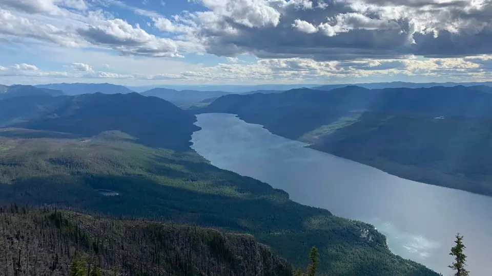
Lake McDonald occupies a valley carved by a massive glacier during the last ice age. As the ice advanced and retreated over thousands of years, it ground down through the mountains, gouging a deep U-shaped trench far wider and deeper than any river could cut on its own. When the glacier finally retreated, it left behind a pile of rock and debris — a terminal moraine — at the valley's western end, near present-day Apgar. That moraine still acts as a natural dam today, holding back the meltwater and runoff that fill the lake. There is no artificial dam and no water management structure; the lake's level is entirely a product of snowmelt, rainfall and evaporation.
Why Is Lake McDonald So Deep?
The lake's depth comes from a process geologists call over-deepening. Valley glaciers don't just scrape the surface — under enough mass and pressure, the ice erodes bedrock well below the level that a river or stream ever could, especially where the ice was thickest and moving fastest through the middle of the valley. That's why Lake McDonald's deepest point sits roughly near the center of the basin rather than close to either shore. The same over-deepening process explains why so many glacially carved lakes around the world — from the fjords of Norway to the Finger Lakes of New York — are dramatically deeper than their surface width would suggest.
How Lake McDonald's Depth Compares
At 472 feet, Lake McDonald is deeper than Flathead Lake to the south — Montana's largest lake by surface area — despite covering a fraction of the surface area. That's a direct reflection of how dramatically glaciers scoured this particular valley compared to the broader, shallower basin Flathead Lake sits in. Within Glacier National Park itself, Lake McDonald is both the largest and the deepest of the park's roughly 700 lakes and ponds, most of which are small, shallow alpine tarns carved at much higher elevation.
Two Strange Things Hidden Beneath the Surface
Lake McDonald's depth hides two well-documented curiosities, and they're often confused with each other.
The Underwater Forest at Sprague Creek
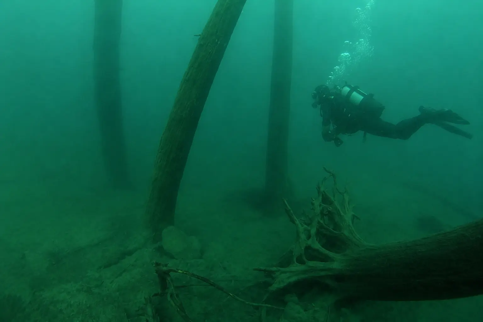
About 100 yards off the picnic area at Sprague Creek Campground, a stand of trees still stands rooted in the lakebed, submerged in roughly 50–70 feet of water. They aren't ancient relics from before the glacial lake existed — radiocarbon dating by paleoclimatologist Dr. Scott Stine puts them at only about 200 years old. The trees grew during a historic drought that dropped the lake's water level enough to expose ground near Sprague Creek; when the drought ended and water levels rose again, the young forest was submerged and preserved in the cold water rather than rotting away. Divers report similar rooted, drought-era trees at Multiple Lakes and McGee Meadows elsewhere in the park — part of the same regional climate record.
The "Shovel Garden" at Apgar
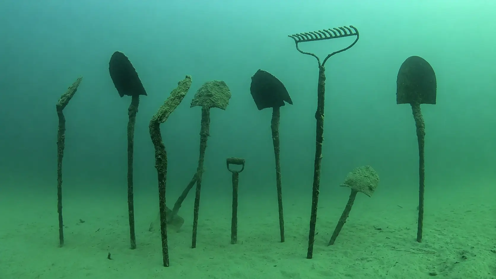
A different — and more recent — kind of underwater relic sits just offshore of Apgar Village: a scatter of picks, shovels and other tools left behind by crews building Going-to-the-Sun Road in the late 1920s and early 1930s. Rather than hauling worn-out equipment back out, workers simply left it in the shallows, where it still sticks up out of the mud today. It's a favorite sight for snorkelers and divers exploring the Apgar shoreline, and it's frequently what people mean when they picture something "sunken" in Lake McDonald — there's no confirmed shipwreck in the lake, just decades of construction-era debris.
The lake's extreme depth is also part of why the water looks so blue-green from a boat — clear water absorbs red light and scatters blue as it gets deeper. Read the full water clarity explanation →
Elevation & Location
Lake McDonald's surface sits at 3,153 feet (961 meters) above sea level on the west side of Glacier National Park, in northwestern Montana. The surrounding peaks rise thousands of feet higher, feeding the lake with cold snowmelt and runoff year-round — part of why the water stays so cold even in peak summer. For coordinates, nearby towns and how to get here, see the Lake McDonald location guide.
Frequently Asked Questions
How deep is Lake McDonald?
Lake McDonald reaches a maximum depth of 472 feet (144 meters), making it the deepest lake in Glacier National Park and one of the deepest in Montana. That depth is the result of glacial erosion — the same ice sheet that carved the surrounding valley also scoured the bedrock far below what is now the lake surface. The deepest point sits roughly near the center of the basin, not near either shore.
What is Lake McDonald's elevation?
Lake McDonald's surface sits at 3,153 feet (961 meters) above sea level, on the west side of Glacier National Park. The surrounding peaks rise thousands of feet higher, which is part of why the lake stays so cold — it's fed by snowmelt and runoff from much higher elevations.
How was Lake McDonald formed?
Lake McDonald was carved by a massive valley glacier during the last ice age, roughly 12,000 years ago. As the glacier advanced and retreated, it gouged a deep U-shaped trench through the mountains — a process called over-deepening — and left behind a terminal moraine of rock and debris at the valley's western end. That moraine acts as a natural dam, holding back the meltwater that became the lake. There is no artificial dam or water management structure.
Is there really an underwater forest in Lake McDonald?
Yes. Near Sprague Creek Campground, a stand of trees still stands rooted in the lakebed in 50–70 feet of water. Radiocarbon dating shows they're only about 200 years old — they grew during a historic drought that temporarily lowered the lake, then were submerged and preserved when water levels rose again. They're not remnants from before the glacial lake formed. Separately, near Apgar Village, divers also find a scatter of tools abandoned by Going-to-the-Sun Road construction crews in the late 1920s and early 1930s — a different, much more recent underwater curiosity that's often confused with the forest.